|
Some Valley residents who take a historical view think of the river as
a link to their early Acadian heritage. It appears that others, however,
make connections between the St. John and the more recent past they themselves
have known in the Valley. During a 1993 focus  group
in Van Buren participants were asked to group similar items printed on
cards. One person placed the "St. John River" with "Acadian migration
and settlement." The St. John River was placed in its own group by two
respondents because it divides two countries. Another associated the St.
John River with "woods/forest" because, "I remember when the wood used
to come down the St. John River, and I used to love and go see that in
the spring." group
in Van Buren participants were asked to group similar items printed on
cards. One person placed the "St. John River" with "Acadian migration
and settlement." The St. John River was placed in its own group by two
respondents because it divides two countries. Another associated the St.
John River with "woods/forest" because, "I remember when the wood used
to come down the St. John River, and I used to love and go see that in
the spring."
During the latter half of the 20th century, Maine Acadians turned their
backs on the river. For instance, today there are few public landings
on the Maine side and views of the river from public vantage points are
infrequent, given the 70-mile length of the study area. Boating is generally
limited to recreational use of area lakes. Water quality varies from pristine
through several degrees of pollution.
During the past few years there has been a growing concern for the future
of the river and the surrounding environment. There are proposals to develop
riverfront parks and to increase public access to the water. A local land
trust was formed in Fort Kent in 1991 and another in Van Buren in 1993.
Local schools have implemented a river awareness program focused on the
natural history and environmental quality of the St. John River. In describing
why she likes living in the Upper St. John River Valley, Shelley Chasse
(a student at Dr. Levesque Elementary School in Frenchville, Maine) expressed
the connections to and concern about the natural environment shared by
many Valley residents (Schaner 1993: 18):
I like living in the St. John Valley now because there is a lot
of fish. We can go ice fishing in the winter. My family can go for a
boat ride. We can go camping. It is also pretty here. We can tell the
seasons--winter, fall, spring, and summer. . . . In the year 2000 I
don't think it will be as pretty as now. There would be much more pollution.
The rivers would be dirty and the fish would die. I would hope that
the Valley will remain clean with its natural resources such as trees
and flowers; and clean of pesticides; and that there would be more jobs
for our community; and that people would be happy in their jobs and
in what they do."
 The
Fish River drainage, which drains into the St. John, includes a chain
of lakes important to Maine Acadians historically and today for economic,
recreational, and aesthetic reasons. The two largest lakes among the series
are Eagle Lake (5,581 acres) and Long Lake (6,000 acres). Eagle Lake is
home to the town of the same name, and the village of St. Agatha is located
on the shores of Long Lake. Both are deep (136 and 163 feet, respectively)
and cool, providing excellent salmon and trout habitat. The
Fish River drainage, which drains into the St. John, includes a chain
of lakes important to Maine Acadians historically and today for economic,
recreational, and aesthetic reasons. The two largest lakes among the series
are Eagle Lake (5,581 acres) and Long Lake (6,000 acres). Eagle Lake is
home to the town of the same name, and the village of St. Agatha is located
on the shores of Long Lake. Both are deep (136 and 163 feet, respectively)
and cool, providing excellent salmon and trout habitat.
 The
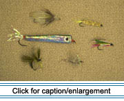
Fish River chain of lakes is at the top of the list for most local anglers,
but recreational fishing is popular throughout the region. There are widespread
fly patterns tied by local fishermen like Pat Roy of Eagle Lake. Some
of the most popular forms include the "black fly" and the "mosquito,"
both of which closely resemble their natural counterparts. In addition
to open-water season, fishing is extremely popular during the winter,
when fish houses are pulled out onto the frozen lakes and holes are sawn
or drilled in the ice for fishing. The
Fish River chain of lakes is at the top of the list for most local anglers,
but recreational fishing is popular throughout the region. There are widespread
fly patterns tied by local fishermen like Pat Roy of Eagle Lake. Some
of the most popular forms include the "black fly" and the "mosquito,"
both of which closely resemble their natural counterparts. In addition
to open-water season, fishing is extremely popular during the winter,
when fish houses are pulled out onto the frozen lakes and holes are sawn
or drilled in the ice for fishing.
|

