|
 The
arrival of Maine Acadians imposed a new order on the land of the Upper
St. John Valley. Initial land ownership in the Valley was granted by the
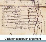
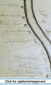
British Crown. In 1790, Joseph Mazerolle and 49 others received 74 lots,
53 of which were occupied. A second grant was issued to Joseph Soucy and
23 others in 1794 (Craig 1988: 127). The early grants followed a long-lot
pattern: each farm was approximately 1,000 feet wide (60 rods), a mile
and a half long, and perpendicular to the river. The early land grants
by the British produced a linear pattern that is similar to land division
elsewhere in Maine and in French Canada; it provided access to rivers,
lakes, and coastal bays and their associated floodplains and tidal marshes.
The patterns of the Valley may be distinctive in the U.S., however, due
to tiers of lots ranging successively back from the river. Further investigation
is required to discern the distinguishing characteristics of Valley land
division. The
arrival of Maine Acadians imposed a new order on the land of the Upper
St. John Valley. Initial land ownership in the Valley was granted by the
British Crown. In 1790, Joseph Mazerolle and 49 others received 74 lots,
53 of which were occupied. A second grant was issued to Joseph Soucy and
23 others in 1794 (Craig 1988: 127). The early grants followed a long-lot
pattern: each farm was approximately 1,000 feet wide (60 rods), a mile
and a half long, and perpendicular to the river. The early land grants
by the British produced a linear pattern that is similar to land division
elsewhere in Maine and in French Canada; it provided access to rivers,
lakes, and coastal bays and their associated floodplains and tidal marshes.
The patterns of the Valley may be distinctive in the U.S., however, due
to tiers of lots ranging successively back from the river. Further investigation
is required to discern the distinguishing characteristics of Valley land
division.
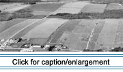
After settlement of lots in the premier rang, the first row of
lots fronting the river, the deuxiÉme rang (second row) lots were
developed. On the north side of the river, settlement continued to at
least six tiers in some places. Because of the curves in the river, these
rangs became oddly juxtaposed, producing an irregular pattern of
land ownership.
On the south side of the river, in what is now Maine, settlement expanded
in this manner in some places until a quatriÉme rang (fourth row)
was established. After the United States acquired jurisdiction over the
south side in 1842, land there ceased to be granted according to the long-lot
pattern. Subsequent land holdings, granted usually to the descendants
of the original settlers or occasionally to new settlers arriving in the
Valley, consisted of a grid system formed by generally square lots of
180 acres each. The square lots represent the American practice of subdividing
square townships. The squares are evident in the Valley today, juxtaposed
with the earlier long, rectangular lots (See map below.)
 Under
the terms of the Homestead Act of the State of Maine, homesites could
be secured fairly cheaply, but the new owners were required to settle
duties and perform road labor before land certificates were issued. Each
certificate or grant was called une concession by local French-speakers.
These grants became known as les concessions, and the neighborhoods
associated with them became known as "back settlements." Though the land
parcels in the back settlements are shaped differently from the initial
tiers, neighborhoods continued to develop in the dispersed linear form.
Their orientation may have been toward the shore of one of several large
lakes or toward a road. Like the initial rang communities, the
small back settlements consisted almost entirely of multi-generational,
extended-family groupings. Under
the terms of the Homestead Act of the State of Maine, homesites could
be secured fairly cheaply, but the new owners were required to settle
duties and perform road labor before land certificates were issued. Each
certificate or grant was called une concession by local French-speakers.
These grants became known as les concessions, and the neighborhoods
associated with them became known as "back settlements." Though the land
parcels in the back settlements are shaped differently from the initial
tiers, neighborhoods continued to develop in the dispersed linear form.
Their orientation may have been toward the shore of one of several large
lakes or toward a road. Like the initial rang communities, the
small back settlements consisted almost entirely of multi-generational,
extended-family groupings.
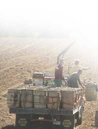
The 19th-century development of les concessions for agriculture
was limited by the fact that the State of Maine had sold most of the remaining
uncleared land during the 1860s and 1870s to large landowners for the
timber (Craig 1988: 132). While the supply of agricultural land shrank,
a flourishing lumber industry developed, providing an economic alternative
to sons who did not inherit land from their parents and who otherwise
would have had to leave the Valley to earn their livelihood.
|
 |
 |
Nineteenth century farmers in the Upper St. John Valley generally did
not subdivide their land holdings among their children. When parents grew
old, they usually adopted one of two strategies. Many exchanged their
farm, its livestock and equipment, for maintenance in their old age. It
was usually a son who entered into the "deed of maintenance," but some
couples chose unrelated individuals. Other elderly couples sold most of
their land to obtain retirement income. In most cases they sold some land
to their children, but it sometimes happened that all the land was sold
to non-family members (Craig 1991: 221-222).
 Lots
initially granted by the Crown were evaluated by the Americans following
the Webster-Ashburton Treaty (1842). The American grants to these lots,
issued by virtue of a provision of treaty, assigned new numbers to the
prior British system and they became known as "treaty lots." Lots
initially granted by the Crown were evaluated by the Americans following
the Webster-Ashburton Treaty (1842). The American grants to these lots,
issued by virtue of a provision of treaty, assigned new numbers to the
prior British system and they became known as "treaty lots."
Similarities do exist between the treaty grants of 1845 and the British
grants of 1790. However, the British numeration of lots began with the
lower numbers downriver and worked up to higher numbers as one headed
upstream. The American numbering system was arranged in an opposite fashion,
with numbers increasing as one headed downstream. It is not always possible
to match lots number-for-number from one system to the other since some
lots in the British system were later divided after the initial grants
were issued and map lines drawn. For example, examination of the succession
of owners of Lot 146, site of the Ernest Chasse House in Madawaska, shows
that the enumeration of treaty lots presents a challenge to researchers.
In this case, determining successive ownership is further complicated
due to errors made in the numbering of this lot and nearby lots.
 Nonetheless,
a record of succession of ownership was compiled, from 1846 to the present,
by Dubay (Brassieur 1992) for the Chasse House and seven others. The following
descriptions of three properties include a "river lot" developed in the
initial rang, a "treaty lot" developed after the establishment of the
international boundary, and a lot in les concessions. In addition
to illustrating land tenure, the descriptions serve as an introduction
to land use in the Valley. Nonetheless,
a record of succession of ownership was compiled, from 1846 to the present,
by Dubay (Brassieur 1992) for the Chasse House and seven others. The following
descriptions of three properties include a "river lot" developed in the
initial rang, a "treaty lot" developed after the establishment of the
international boundary, and a lot in les concessions. In addition
to illustrating land tenure, the descriptions serve as an introduction
to land use in the Valley.
|
|